Johnson's
Crook is located on the western slope of Lookout Mountain
south of Trenton and to the east of Rising Fawn community
in Dade County. The site appears on the Trenton, GA/AL quadrangle
(101-SE) of the U.S. Geological Survey Maps.
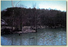
Area of Federal camps along Hurricane Creek at Johnson's
Crook.
HISTORICAL
SIGNIFICANCE
Johnson's Crook is a long, twisting gap created by the waters
of Hurricane Creek coming off Lookout Mountain to merge
with Lookout Creek. During the war, the only road by which
wagons and artillery had a chance of getting over Lookout
Mountain went up Johnson's Crook. On September 5, 1863,
General James Negley, commander of the lead division of
the Army of the Cumberland, sent two infantry regiments
and a section of artillery to reconnoiter the area around
Johnson's Crook. The following day, a regiment explored
the road up the mountain and fought a brief skirmish with
Confederate cavalry, in which one man was wounded. Negley
established a base camp at a spring near the place where
Hurricane Creek enters Lookout Creek.
"I have
just returned from the top of the mountain," General Negley
reported on September 7. "The road is very steep and rough
in places. To get up our trains will be a laborious undertaking.
We are improving the road as much as possible. We gained
possession of the top and cross-roads 2 miles beyond without
opposition. The enemy attempted an ambuscade at the cross-roads,
but was frightened off by an effort I was making to get
into his rear."
|
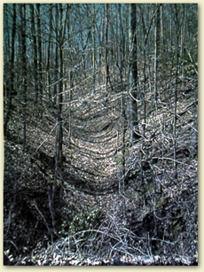
A
portion of the wartime road up the mountain at Johnson's
Crook.
On September 9th General Negley led his division over the
mountain at Johnson's Crook. For the next week there was
a steady stream of men following up the mountain. On September
16th the historian of the 73rd Illinois Infantry wrote:
"At 10 a.m. the regiment started up the mountain, leaving
eight men with each wagon to help the mules up the steep
road with the train. It required the putting forth of the
utmost strength of the mules and men to get the train over
the most difficult places in the road. On getting fully
half-way up the mountain we came to a small field, an orchard,
and an old log hut. In the hut was a poor, helpless woman,
suffering from intermittent fever. She was lying on a very
scant and rickety bed, and had an army blanket for her covering.
There was no furniture in the house. A part box of army
crackers, some coffee and sugar had been left by the passing
soldiers for the woman and her two small children to subsist
on. The husband and father had been killed in the rebel
army some six months previously. The floor of the old hut
being partly gone, and some of the spaces between logs of
the sidewalls being not less than ten inches wide, together
with the suffering and poverty within, made the house a
sad one to contemplate. Shortly after twelve noon we reached
the top of the mountain. Had time for rest and coffee. A
mail was also unexpectedly and joyfully received."
|
The
men of the Army of the Cumberland continued the trek up Johnson's
Crook and over Lookout Mountain. The last unit did not get
over the mountain until November 18th -- the day before the
big battle at Chickamauga.
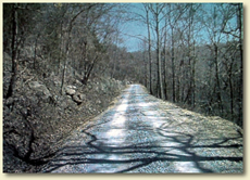
A modern road going up Lookout Mountain that follows closely
the wartime road used by the Federal army to cross the mountain
in 1863.
References:
Official Records of the War of the Rebellion
Archive and files Chickamauga and Chattanooga National Military
Park Raymond Evans, The Civil War in Dade County
Significant
Views: A good viewshed for this property exists along
the Newsom Gap Road in the Johnson Crook area. This road is
not in the exact position, but is close to where the armies
went over Lookout Mountain.
Setting:
The site is located in largely unspoiled forest. Nevertheless,
the growing residential density along the west brow of Lookout
Mountain could have an increasing negative impact on the rural
setting of the surrounding area.
Documented
Structures, Sites and Features: The only features are
the natural attractions that the men saw during the war.
Presumed
Wartime Features: This was the major staging area for
the Federal Army of the Cumberland on their way over the mountain.
There are numerous short term camp sites in the vicinity.
Original
Terrain: The general terrain in the vicinity of this site
still retains much of its wartime condition.
Related
Sites: Cloverdale Plantation, and Cureton's Plantation.
|